Jeju Island

Cheju Island, alternately known as Chejudo or Jejudo, is an oval-shaped volcanic landmass covering 1,845 square kilometers (712 square miles) off the southern tip of the Korean Peninsula.

Jiuzhaigou Valley of China

Jiuzhaigou, which means "Valley of Nine Villages", is regarded as one of the most beautiful place in China. This nature reserve is located on the north of Sichuan province in central China, bordering on Tibet.

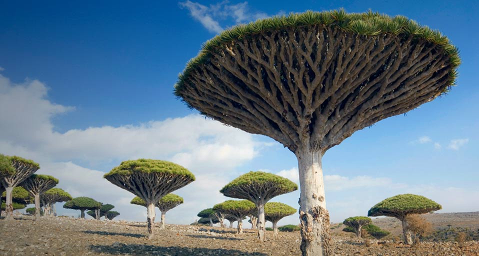
Socotra Island, Yemen

Socotra Island is an attractive natural landscape. God bestowed it with distinct bio-diversity rich in creatures and beautiful plants..

Manafaru Beach of Maldives

Manafaru Beach (5star Hotel) sits at the most northerly tip of the Maldives, idyllically set on a 14 hectares of private island within the unspoiled beauty of the Haa Alif atoll in northern Maldives, is surrounded by a colorful coral reef worth exploring and little explored by foreigners and totally un-polluted by the noise of passing speedboats and is just about the most tenuous country on Earth.

Showing posts with label Asia. Show all posts

Halong Bay

3:46 AM

Halong Bay Located in the northeastern part of Vietnam and constitutes part of the western bank of Bac Bo Gulf, including the sea area of Ha Long City and Cam Pha Town and part of Van Don island district. It abuts Cat Ba Island in the southwest.

Halong literally means “descending dragon,” and there’s a local legend that says that when the Vietnamese were fighting foreign invaders long ago, the gods sent a family of fighting dragons to help them defend the land. As the dragons descended upon the area, they spit jewels and gems, and when these hit the water, they turned into little islands, which today dot the bay.
Halong Bay has twice been recognized as world natural heritage by UNESCO. The first time is for Halong bay's beauty landscapes. The second time is for Halong bay's geology formation. Magnificent Halong bay Vietnam is One of 7 must-visit places on the earth.

Ha Long Bay is a complex of offshore islands being one of the most typical examples of marine-invaded tower karsts. The Bay consists of more than 1.600 islands and islets hiding inside many spectacular caves and grottoes with stalactites and stalagmites. The bay’s sublime & magnificent beauty sets it apart from other sites and is drawing millions of cruisers every year.

Getting there
By air: Halong Bay is 1 hour flight by helicopter from Gia Lam Airport in Ha Noi.

By road: Halong Bay is 160km or 3.5 hours drive from Ha Noi. The road is fairly good, though traffic may be very busy. There are many local bus companies from commuting between Ha Noi - Halong City. The buses don't have seat number and the driver may stop many times to pick up more passengers on the way until it's totally stuffed. Also all commuter bus drivers have to hurry to pick up as many people as possible on the way; they drive very recklessly.

Halong Bay can also be visited by road from Hai Phong. It's only 70km between the 2 cities and the drive takes 1 hour.

By boat: From Hai Phong you can take a speed boat for 1 hour to Cat Ba where you take a 5 hour boat cruise weaving through Halong Bay islands.

When to go

The best time to travel Halong is from October to April when the weather is pretty pleasant. In summer, it's hot, humid and rainy, while monsoons flourish. In winter, it's cold, dry, and sees little rainfall.

Halong Bay is also one of the new 7 Wonders of the World.

Jeju Island

1:00 AM


Cheju Island, alternately known as Chejudo or Jejudo, is an oval-shaped volcanic landmass covering 1,845 square kilometers (712 square miles) off the southern tip of the Korean Peninsula. Geologists estimate the island’s age at 2 million years, and archaeological finds suggest that people have lived on the island since prehistoric times. Today, Cheju is both a tourist attraction and home to a United Nations Educational, Scientific and Cultural Organization (UNESCO) World Heritage site.
 Originally Jeju was an independent country called Tamna. In 662AD Jeju became a province of Goryeo which was a part of present day South Korea. In 1121 Tamna was renamed Chejudo or Jeju Island. In 1910 Jeju and Korea were occupied by the Japanese. After the Second World War Jeju became a province of the Republic of Korea.
Jeju Island is Korea’s most famous local honeymoon destination and can be considered as Korea’s equivalent of Hawaii. It takes only one hour by flight from Seoul to Jeju Island. It is also frequently visited by foreign tourists particularly those from Japan and China. Besides that, Jeju is also frequently used as a filming site for Korean dramas such as All In and Dae Jang Geum. The hit movie Shiri was also filmed here.

Jejudo Island is sometimes referred to as “Samdado Island” which means “three many” because of its abundance of rocks, women, and wind. It also has a dormant volcano, Mt. Halla, which rises more than 6,397 feet (1,950 meters) above sea level. 360 satellite volcanoes are around the main volcano.

On this island, there are many women divers known as haenyeo. They age between 40 and 70 years old, and dive into the ocean to search for abalone, shellfish and seaweed to sell. The amazing thing is that they dive into the ocean without any oxygen tanks. Unbelievable but true!


Jeju island is filled with palm trees, mountains, volcanic tubes and amazing beaches. You can go scuba diving, hiking, sightseeing, museum-hopping, horseback riding, hot-air ballooning, water-sliding, or a million other adventures.

It's truly a must-see if you're in Korea for work or travel. Come for a weekend or a week, it's easy and cheap to get there on a quick flight from Seoul on one of the many discount carriers. Or, you can take the ferry from Busan or Mokpo as well. Visitors to Korea often list Jeju Island as their favorite part of the trip.

Puerto Princesa Underground River

6:31 AM

The Puerto Princesa Subterranean River National Park ( Also previously known as the St. Paul subteranean river) is a UNESCO World Heritage Site located about 50 kilometers north of the city of Puerto Princesa in the province of Palawan, Philippines. It contains the renowned Subterranean River, thought to be the longest navigable underground river system in the world. The National Park is part of the Saint Paul Mountain Range situated on the northern coast of the island.

The Puerto Princesa Subterranean River National Park features a limestone karst mountain landscape with an 8.2 km. navigable underground river. A distinguishing feature of the river is that it winds through a cave before flowing directly into the South China Sea. It includes major formations of stalactites and stalagmites, and several large chambers. The lower portion of the river is subject to tidal influences. The underground river is reputed to be the world's longest.

The area also represents a significant habitat for biodiversity conservation. The site contains a full mountain-to-the-sea ecosystem and has some of the most important forests in Asia.

Tourism

Because of its natural wonders, the Puerto Princesa Subterranean River National Park is a key destination for local and international tourists alike. According to the Palawan Council for Sustainable Development website, the park gets an annual income of about Php 5 million. This finances the maintenance, managed by the Protected Areas Management Board (PAMB) headed by the City Government of Puerto Princesa.

Travel Advisory


In order to get to the National Park, you must take the Puerto-Roxas road which goes all the way to Sabang, where the park is located. There are also daily buses which leave Puerto Princesa's San Jose bus terminal at 7am, and fare costs are at around Php 300. Two or three jeepneys also take the same route, leaving the terminal at the same time, but are cheaper at Php 200. Trips take three hours.

To explore the Subterranean River, one must secure a permit at the Tourist Information and Assistance Center at the Sabang pier. This costs Php 150 for Filipinos and Php 200 for foreigners. The office can also arrange boat transport to the river (round trip P700, 15 minutes). Then after a five minute walk to the actual entrance, you will be given a lifejacket and helmet, and assigned a boat and driver for the trip to the cave.
The boat ride takes you inside the cave for only about 5 kilometers, since beyond this the river becomes difficult to navigate. The round trip takes about 45 minutes. Cameras are allowed.

History

The PPSRNP was established on March 26, 1971, by virtue of Presidential Proclamation No. 835 issued by the late President Ferdinand E. Marcos. Formerly known as the St. Paul Subterranean National Park, it initially comprised of 3,901 hectares of terrestrial reservation. To ensure long-term viability, former President Joseph E. Estrada signed Proclamation No. 212 on November 16, 1999 expanding the area of the Park to 22,202 hectares that now includes the entire catchment for the Underground River and significant forest important for biodiversity conservation.

It was also renamed to Puerto Princesa Subterranean River National Park to properly identifying it with the place. The PPSRNP was also declared as a National Geological Monument on December 11, 2003 by the National Committee on Geological Sciences (NCGS).

Pamukkale

10:23 PM

Located 20 kilometers from the town of Denizli in the Aegean region of Turkey, Pamukkale is one of the most interesting places in the world, justly famous not only for the entrancing beauty of its unique geological formations but also for its historical remains.

Pamukkale has always been a very popular settlement where the hot springs were believed to have healing powers, so the city became the center of a pagan cult in antiquity and a spa resort today.
The city was on the borders of Caria, Lycia and Phrygia and had a mixed population. Citizens were usually involved in the wool industry and little has changed as it is still a textile center.

The calcium oxide-rich waters flowing down the southern slope of Caldag located north of the ruins have, over the millennia, built up deposits of white travertine on the plateau thus fully justifying both the site's ancient name of Hierapolis (Holy City) and its modern one of Pamukkale (Cotton Castle).

Ancient Hierapolis appears to have been founded by King Eumenes II of Pergamon and its name is derived from Hiera, the wife of King Telephos, the legendary founder of Pergamon. The city became subject to Rome in 133 BC. In 17 BC. during the reign of Tiberius it suffered a heavy earthquake that substantially destroyed the city, requiring it to be rebuilt. In the 2nd and 3rd centuries, it reached the height of its development as a Roman thermal bath center.The temperature of water is like 33°C -35,5°C .

Perhentian Island

8:23 PM

 Perhentian Island or Pulau Perhentian - Lying just 18 kilometre from Jertih Terengganu and 60 from Kota Bharu Kelantan in Peninsular Malaysia. This beautiful island is famous among travelers for its soft sandy beaches and laid back lifestyle. Perhentian Island is accessible from the small fishing port of Kuala Besut, 25 minutes by speed boat or a leisurely 90 minute sea journey by colorful traditional boat.

Perhentian is warm and tropical with some of the best beaches in the region. The Island has over 20 fringing reefs, great for scuba diving and snorkelling.

There are two small islands that form the Perhentian Islands. The names are Perhentian Besar, the larger of the two and popular among couples and families with children, and Perhentian Kecil, the smaller island and very popular among budget travelers

The two jewels located 45 min away by boat from the Est seaside of North of Malaysia. As a consequence, it is in the China Sea we can swiw there. These two twin islands are a part of Terrenganu State, but we have to cross Kelantan State to reach them, which is located at the extreme North of Malaysia, and has a borderline with Thailand. This State, as his neighbour State, is a rigorist islamic State, where for instance the law forbid alcohols.

The islands have a number of activities on its beaches and forests, with the most popular being snorkeling and scuba diving. The more relaxing pursuits are sunbathing and swimming and, apart from these, the island also offers activities like canoeing, jungle trekking, fishing and island hopping.

Owing to the islands' protected status, the main tourist activities have minimal environmental impact. This makes Pulau Perhentian famous in the region for its stunning preserved natural world and diverse marine life.

The best time to visit
The monsoon season peaks between November and March every year. You can expect more rain and rough seas and most resorts are typically closed from end October through end-February. Peak season is between July and August and prices rise accordingly. During off-peak times, rates are negotiable. You may need to book well in advance during peak time and also for public holidays and weekends. Note that most budget resorts do not accept bookings and handle guests on a walk-in basis only.

Climate
Equatorial with fairly uniform temperatures year-round, ranging from 21ºC (70ºF) to 32ºC (90ºF). Humidity is high (85-95%). Annual rainfall varies from 2,000mm to 2,500mm and most rain can be expected between November and February.

Mauritius Island

1:37 AM

 Mauritius (Île aux Cerfs Island) is a small tropical island situated in the turquoise southwest Indian Ocean. Mauritius measures 67 km ( 42 miles) in length and 46 km ( 29 miles ) at its widest point. With an area of approximately 1860 square kilometers ( 730 sq miles ), the size of Mauritius equals about that of the English county of Surrey or South Africa's Cape Peninsula and False Bay.

Mauritius was discovered in 1505 by a Portuguese sailor but was then conquered by the Dutch, French and British. The country gained independence in 1968, has grown into a developing country and has one of Africa's highest per capita incomes.

Mauritius, a volcanic island of lagoons and palm-fringed beaches in the Indian Ocean, has a reputation for stability and racial harmony among its mixed population of Asians, Europeans and Africans. Although the volcanoes in Mauritius are no longer active, they have left their mark on the profile and landscape of this island featuring the mountain peaks in the west as well as several volcanic craters. Although Port Louis which is located in the northwest of Mauritius is the capital and the center of business activity, the people prefer to live in the coolness of the nearby towns and suburbs of the plateau, such as Quatre Bornes, Curepipe, Rose Hill/Beau Bassin and Vacoas/Phoenix.

Mauritius is the perfect holiday destination with no visa or vaccinations needed and with only 3 hours time difference there's no jet lag to worry about. Temperatures stay high all year round so you know your holiday to Mauritius will be sunny and warm whenever you go.

Climate
Tropical, modified by southeast trade winds; warm, dry winter (May to November); hot, wet, humid summer (November to May); Natural hazards : Tropical cyclones (November to April);but most cyclones usually occur from the end of December until March. Mauritius has only two seasons, winter and summer. There is not much temperature differences between the two seasons of the year.

hawa mahal, Jaipur

7:09 PM

Hawa Mahal is a major landmark and a famous tourist attraction of Jaipur. The Palace offers a beautiful sight to behold. The splendid Rajputana architecture of Hawa Mahal, still speaks the glory of the royal family. However, one can also find a glimpse of Mughal architecture, which is blended perfectly to make it different from others. The literal meaning of Hawa Mahal is Palace of Winds.The palace was designed by Lal Chand Usta, who also planned Jaipur city or Pink city. Its unique five-story exterior is also comparable to the honeycomb of the beehive with its 953 small windows that are decorated with intricate lattice work. Hawa Mahal was built by Maharaja Sawai Pratap Singh in 1799.

It is beautifully outlined with white borders and its motifs are painted with quick lime. The monument provides a spectacular view of Jaipur city overlooking the road avenues, intersections and colorful crowds in the market. It was originally conceived in the era when ladies lived behind veils and screens so that the ladies of the royal household can see glimpses of the everyday life and the royal processions in the city without being seen by others.

The architectural design is based on certain scientific principle. Hot wind becomes cool when contracted. Hawa mahal has hundreds of small sized windows. Hot wind compressed while entering through the small sized windows and becomes cool. Hence, air enters into the palace is always cool irrespective of weather. The Royal family of Jaipur used to come and live in Hawa mahal during summer season and hot summer days. There was a famous program of music broadcasted through radio named Hawa mahal. This shows the popularity of this palace.

Early morning is considered as the best time to visit the Palace, when it is drenched in the golden light of the Sun. At this time, Hawa Mahal appears incredible. One cannot possibly describe the beauty of the Palace in words. The golden light of the early morning sun floats beautifully through the windows of this palace creating a wonderful sight for one and all. The palace has to be visited to experience the true beauty.

Burj Al Arab

7:05 AM

The World's Tallest - and only "7 Star" - Hotel

Construction
Construction of Burj Al Arab began in 1994. It was built to resemble the sail of a dhow, a type of Arabian vessel. Two "wings" spread in a V to form a vast "mast", while the space between them is enclosed in a massive atrium. Architect Tom Wright said "The client wanted a building that would become an iconic or symbolic statement for Dubai; this is very similar to Sydney with its Opera House, or Paris with the Eiffel Tower. It needed to be a building that would become synonymous with the name of the country."

The architect and engineering consultant for the project was Atkins, the UK's largest multidisciplinary consultancy. The hotel was built by South African construction contractor Murray & Roberts.The hotel cost $650 million to build.
The Burj-Al-Arab is a luxury hotel in Dubai, United Arab Emirates. At 321 meters (1,053 feet), it is the tallest building used exclusively as a hotel and one of the most distinctive structures for a hotel building in the world. It stands in the sea on an artificial island 280 meters (919 feet) away from the beach in the Persian Gulf, connected to the mainland only by a curving path. The path is extremely curving, with most corners being almost 90 degrees.

Rooms and prices
Despite its size, the Burj Al Arab holds only 28 double-story floors which accommodate 202 bedroom suites. The smallest suite occupies an area of 169 square meters (1,819 square ft), the largest covers 780 square meters (8,396 square ft). It is one of the most expensive hotels in the world. The cost of staying in a suite begins at $1,000 per night and increases to over $15,000 per night; the Royal Suite is the most expensive, at $28,000 per night

Suites feature design details that juxtapose east and west. White Tuscan columns and a spiral staircase covered in marble with a wrought-iron gold leaf railing show influence from classicism and art nouveau. Spa-like bathrooms are accented by mosaic tile patterns on the floors and walls, with Arabian-influenced geometries, which are also found elsewhere in the building.

How to visit
As its web site describes it, "Burj Al Arab is located in the Jumeirah Beach area of Dubai, 15 km. from the main city centre and 25 km. from Dubai International Airport. It is well served by taxis and has its own fleet of 10 chauffeur driven Rolls-Royces. It stands proudly on a man-made island some 280m. offshore and is linked to the mainland by a slender, gently curving causeway."

To cross the causeway, however, you need a reservation at the hotel. Casual visitors are not admitted, and reservations - even for a meal - require almost as much advance notice as they do cash.
Even if you don't make it across the causeway, there are great views of the building from the shoreline, including the neighboring Jumeirah Beach hotel and Madinat Jumeirah, which are both also luxury hotels but physically more accessible.

Pearl Farm Beach Resort, Davao

9:13 PM

The Pearl Farm is located on Samal Island just a short boat ride from Davao City. The 11-hectare resort was once a real pearl farm that cultivated oysters imported from the Sulu Sea, and produces some of the best pearls in the country. Now the white sand beach resort is a top tourist attraction in Davao del Norte with cottages inspired by Isamal native design.

The Pearl Farm Beach Resort is situated on the isolated Samal Island, a 45 minute boat ride from Davao City. This private resort is surrounded by coconut palms and a white sandy beach. It offers quite and relaxation plus a choice of watersports for the more active. Rooms are in a traditional natural style blending in with the idyllic surroundings.

Today, the resort has 73 fully air conditioned luxurious guestrooms, suites, cottages, and villas that sit around the contour of the island. Perched above the sea, the rooms and villas afford a breathtaking panoramic view of the deep blue waters of Davao Gulf. Each room is furnished with cable television, telephone, coffee/tea maker, mini bar, and room safe. The private toilet and bath are provided with hair-dryers.The villas were exquisitely designed from Maranao and Samal ethnic influences in both materials and forms. The facilities include outdoor swimming pools, tennis courts, badminton courts, basketball courts, souvenir gift shops, a luxurious health spa, a cocktail bar with the view of the sea and nearby islands, a restaurant that serves delicious Filipino and international cuisines of fresh seafood specialties, and fully equipped function rooms and boardrooms, and many others.

Sports enthusiasts, and first-timers alike can enjoy the challenges of wind surfing, water polo, jet-skiing, water-skiing, banana boat rides, scuba diving, sea-kayaking, Hobie Cat surfing, and even underwater photography.

Atlantis Paradise Island

9:51 AM

Atlantis Paradise Island, a resort and waterpark, is located on Paradise Island. The island contains the Royal Towers which is joined by the Bridge where the Bridge Suite is located. This suit is considered as the most expensive hotel suite in the world. A one night stay here costs a jaw-dropping $25,000.

Officially opened in 1998, the resort was created by South African hotel magnate Sol Kerzner and Kerzner International Limited. Paradise Island first opened its Coral and Beach Towers as the Trump Plaza, then changed its name to Atlantis when the Royal Towers were built. The Coral and Beach Towers were later refurbished to match the theme of the Royal Towers. On 28 March 2007 a 600-suite luxury hotel named The Cove Atlantis opened on Paradise Island. Another tower, the 497-room Reef Atlantis, opened 19 December 2007

The Great Wall of China

2:46 AM

As one of the Seven Wonders of the Medieval World, the Great Wall of China is an unmissable highlight of any tour of China.

The Great Wall, built over two thousand years ago, crosses deserts, grasslands, mountains and plateaus. It stretches all the way from the Shanhaiguan (Sharn-Hi-Gwarn) Pass on the east coast to Jiayuguan (Jia-Yoo-Gwarn) on the edge of the Gobi Desert in the west, more than three thousand miles away. Walk on the magnificent Great Wall to appreciate its historical significance and admire the panoramic views, whilst reflecting on the enormity of the material and labour required for its construction.

Unlike other Natural and Cultural Heritage Sites, the Great Wall embraces such broad dimensions that nothing else can compare with. It runs across Northern China from east to west, providing protection to agricultural civilisation and ancient trading routes. It spans the history of China from past to present, witnessing the rise and fall of powers and dynasties.

The Jiankou section of the Great Wall is roughly 22 kilometers in length and consists of three parts. The western part from is from Nine Eye Tower which is the most western point of Jiankou to Jiankou watch tower is 12 kilometers. The middle part from Jiankou watch tower to the Ox Horn Edge is 3 kilometers and the eastern part from Ox Horn Edge to the beginning of Mutianyu is 7 kilometers.

Many parts of the Great Wall are gone, a lot are succumbing to the elements. Some have been buried by the desert, some destroyed by people. Still, the Wall stands silently, enduring the passage of time and greeting the changes of seasons.

The Beijing sections of the Great Wall of China
There are over 10 sections of the Great Wall that are all north of Beijing within a maximum of three or four hours travelling. I have listed the six most popular or impressive sections below with the distance from Beijing then given detailed information on each of the six sections.
Badaling 80 Km
Jiankou 73 Km
Mutianyu 70 Km
Gubeikou 120 Km
Jinshanling 125 Km
Simatai 120 Km

Why the Great Wall of China is special
It is by far mankind's most extensive construction endeavor. In its heyday in the 16th and 17th centuries, it snaked 6400 kilometers or 4000 miles across northern China.

Did You Know?
When Emperor Qin Shi Huang ordered construction of the Great Wall around 221 B.C., the labor force that built the wall was made up largely of soldiers and convicts. It is said that as many as 400,000 people died during the wall's construction; many of these workers were buried within the wall itself.


Jiuzhaigou Valley of China

12:51 PM

 Jiuzhaigou is located at the southern end of the Minshan mountain range, in Jiuzhaigou County (formerly Nanping County) in the Aba Tibetan Qiang Autonomous Prefecture of northwestern Sichuan province, near the Gansu border. The provincial capital, Chengdu, is 330-460km south. The Jiuzhaigou area covers 600 to 720sq km, of which at least 240sq km is the valley, and the remainder are buffer zones.
It is said that if there should be wonderlands on the earth, Jiuzhaigou Valley must be one of them. There is no equal elsewhere that has sceneries and fables of dreamlike eloquence, or natural purities like a fairyland as Jiuzhaigou Valley.
Jiuzhaigou, which means "Valley of Nine Villages", is regarded as one of the most beautiful place in China. This nature reserve is located on the north of Sichuan province in central China, bordering on Tibet. Jiuzhaigou has become China's biggest landscape destinations, this despite having one of the highest entrance fees of any parks in China.
It is a nature reserve in the north of Sichuan, a province in south western China. It is known for its many multi-level waterfalls and colorful lakes. Stretching over the northern part of Sichuan as a jagged alpine valley, Jiuzhaigou offers a spectacular landscape with the composition of turquoise waters, bouncing streams, flying waterfalls and lush forest surrounded by snow-capped peaks. Its nickname is "Jiuzhai Paradise". The remoteness doesn't prevent it from becoming a hot tourist destination.

History
The remote region was inhabited by various Tibetan and Qiang peoples for centuries, but was not officially discovered by the government until 1972. Extensive logging took place until 1979, when the Chinese government banned such activity and made the area a national park in 1982. An Administration Bureau was established and the site officially opened to tourism in 1984; layout of facilities and regulations were completed in 1987. The site was inscribed by UNESCO as a World Heritage Site in 1992 and a World Biosphere Reserve in 1997.

Getting there
The Jiuzhaigou-Huanglong Airport is some 11 kilometers northeast of Chuanzhusi Town, Songpan County of the Aba Tibetan and Qiang Autonomous Prefecture and 88 kilometers from the entrance of the Jiuzhaigou Valley. Tourists in Chengdu can reach the valley directly by air. The Xinnanmen Bus Station and the Chadianzi Bus Station in Chengdu both provide direct daily services to the scenic area. There are also environmentally-friendly buses within the scenic area.
Opening hours
May, 1st – November, 15th 7:00am to 6:30pm
November, 16th – April, 30th 7:00am to 6:00pm

 
  • Followers